
So on that note, something a little more proactive that I have meant to do for a long time, and that is share some decent information about the beautiful cycling option we have out west here. And this is also a great day trip with cafes etc at Altona and Williamstown.
As often as I can, I cycle to work. It is faster, cheaper, and more reliable than a car, bus or train, and I arrive to work on time and with a clear head and having done something to get off my butt. It is a fantastic ride - largely traffic free on shared bike/pedestrian paths, and is very quiet and safe as far as city commutes go. The only real hazards are the odd over excited dog off leash, and a few short sections on the road with some traffic...on a clear morning with the first glows of the sun pouring over Port Philip Bay, it feels like the best commute in the world!
Entry points
..or skip this and look at the route on a map
There are a couple of options for starting this depending on where in Point Cook you are based - but try to avoid the Point Cook roundabout by the Sanctuary Lakes Shopping Centre, which is a major hazard. Point Cook road is seriously dangerous for cyclists despite the intermittent bike lane. Bypass this by:
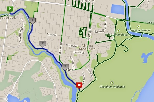
1. If coming from the Laverton end, join the path down Skeleton Creek somewhere - there are numerous entry points. If starting from Skeleton Creek / Seabrook below, add 3.7km:
2.If coming from Salt Water Coast (+5.2km), head down the prom and turn right onto Spencer street. At the end or Oprheus street you can wheel your bike up a small embankment (don't ride it, you'll damage the landscaping) and then connect. up with Sanctuary lakes. You can also use the later part of the route if come from West Point Cook/ Featherbrook/ Alamanda Estates:

From Sanctuary Lakes
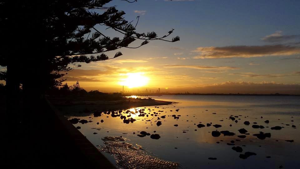
Assuming you've done either one of those, the route starts from Beach Walk off Sanctuary Lakes Boulevard. Cross the footbridge over the creek - on cool and crisp winter mornings there are stunning sunrises, and I make a special effort to stop for a minute - this sure beats sitting in a traffic jam! |
| Winter Sunrise |
Cross the bridge here and you are now traffic free for the next 5 or so km along the wetlands on the shared path to Altona
 |
| Cheetham Wetlands |
 |
| Part of the route |
The route then pops back out onto the road along the Altona foreshore. In the mornings, this road is totally dead from traffic and its another beautiful section of the ride, with more great sunrises!
 |
| Altona Foreshore |
Keep following the road, it degrades badly as you start to run parallel with the railway briefly just past the Alton Boat Harbour, in winter make sure you have decent lights here so you can see the potholes. There is a river ford are Kororoit Creek which is only a problem if it's been raining seriously hard...on those days there may be 1ft of water here but in summer it's totally dry most of the time.
The path then snake around Jawbone reserve - in the mornings here there are people out walking, especially from a nearby old peoples home - so remember it is a shared path, slow down and let them know you are there before passing. I have seen snakes here too, 4 times in 2 years, but nowhere else on the whole route. All 4 times it was on the first hot day in Autumn when they are most active..around October-ish.
 |
| Williamstown Beach on a summer day |
2 options to finish this off:
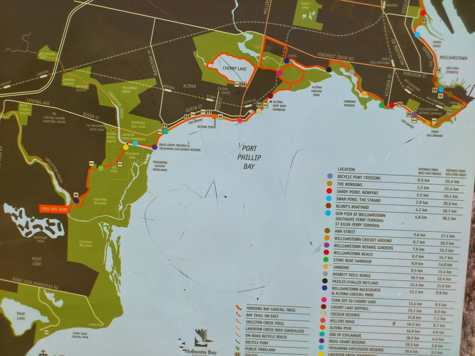
1. Jump on the cyclists ferry the The Punt which runs every 20 minutes just in the mornings and afternoons (timetable on their website) and takes a few minutes to short cut off a fairly unpleasant ride through the docklands industrial area by taking you across The Yarra. The punt is a small cyclist/pedestrian ferry with a bit of a community of like-minded people on board, and often has plenty of good banter going on. It is extremely reliable and I've never seen it not run, even in the direst weather. A $10 card will get you 5 trips + 1 free on weekdays (its more expensive on weekends) or $2 for one way.
The departure point for The Punt is below and before the Westgate Bridge.
 |
| The Punt. Just to set expectations: the one in the foreground... |
Assuming you took option 1, from the Punt landing point it is about more 5km to get into the city Head along Lorrimer St until you get to a left hand turn for Foundary Way. You can then get off the road and ride along the river for the last section. I've measured my route up to the Southbank directly opposite Flinders St station. Be very slow along the Southbank, cyclists have been getting bad press there for being a hazard and its a busy shared area.
And here is the route itself in full.
Summary
Distance: From sanctuary lakes to Flinders St its about 28km. This is not the fastest, most direct route - but I think it is the nicest.Best months to ride: in Autumn the wind is calmer and it is still warm but not hot. My favourite cycling month is April.
Worst months: Spring is the windiest, I don't like October despite it getting warmer! In mid-winter you need good warm gear and good lights as there is NO street lighting on a lot of this route - but once you toughen up winter is no major problem.
Hazards: Dogs off leash. And they are totally invisible in winter. Also a bit of truck traffic in the docks area where you get off The Punt, although there is a lot space.
Cost: Less than $4 return. You'll need a decent breakfast.
Time: Depends on your legs and your attitude! About an hour and a quarter riding + 5 - 10 minutes on The Punt. You could be faster or slower.
Stress facto: Nil.